Census 2000 U.S. Maps
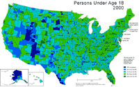
Population Under Age 18, 2000
Description: U.S. population under the age of 18 as a percent of total population by county, 2000.
Format: Color, 11" x 17", landscape.
JPEG
347 kb
PDF
303 kb
Data Source:
U.S. Census Bureau.
Order Code: US-C005
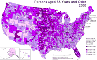
Population Aged 65 Years and Older, 2000
Description: U.S. population 65 years of age and older as a percent of total population by county, 2000.
Format: Color, 11" x 17", landscape.
JPEG
328 kb
PDF
303 kb
Data Source:
U.S. Census Bureau.
Order Code: US-C006
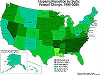
Hispanic or Latino Population: Percent Change (1990-2000)
Description: Hispanic or Latino population by state: percent change 1990-2000.
Format: Color, 8.5" x 11", landscape.
JPEG
115 kb
PDF
113 kb
Data Source:
U.S. Census Bureau
, Census 2000
Order Code: US-C007
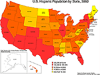
Hispanic or Latino Population, 2000
Description: Hispanic or Latino population by state, 2000.
Format: Color, 8.5" x 11", landscape.
JPEG
119 kb
PDF
113 kb
Data Source:
U.S. Census Bureau
, Census 2000
Order Code: US-C008
<
Previous
1
2
3
4
5
Next
>
Illinois
Basemaps
Agriculture
Climate/Environment
Counties/Metro Areas
Crime/Public Safety
Demographic
Economic
Education
Federal Expenditures
Health/Vital Statistics
Historical
Housing/Construction
Income/Poverty
Labor Market
Physical Features
Political
Recreational
Transportation
United States
Basemaps
Agriculture
Climate/Environment
Crime/Public Safety
Demographic
Economic
Education
Federal Expenditures
Health/Vital Statistics
Historical
Housing/Construction
Income/Poverty
Labor Market
Physical Features
Political
Recreational
Transportation
Utilities
Please report problems to the
webmaster
.
Copyright © 2001-2008 by the
Regional Development Institute
,
Northern Illinois University
.