U.S. Housing and Construction Maps
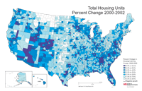
Total Housing Units by County, Percent Change, 2000-2002
Description: Total housing units by county, percent change 2000-2002.
Format: Color, 11" x 17", landscape.
JPEG
258 kb
PDF
309 kb
Data Source:
U.S. Census Bureau, 2003
.
Order Code: US-HC001
Total Housing Units by County, Numeric Change, 2000-2002
Description: Total housing units by county, numeric change 2000-2002.
Format: Color, 11" x 17", landscape.
JPEG
201 kb
PDF
224 kb
Data Source:
U.S. Census Bureau, 2003
.
Order Code: US-HC002
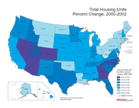
Total Housing Units by State, Percent Change, 2000-2002
Description: Total housing units by county, percent change 2000-2002.
Format: Color, 8.5" x 11", landscape.
JPEG
71 kb
PDF
152 kb
Data Source:
U.S. Census Bureau, 2003
.
Order Code: US-HC003
Total Housing Units by State, Numeric Change 2000-2002
Description: Totle housing units by state, numeric change 2000-2002.
Format: Color, 8.5" x 11", landscape.
JPEG
74 kb
PDF
152 kb
Data Source:
U.S. Census Bureau, 2003
.
Order Code: US-HC004
1
2
Next
>
Illinois
Basemaps
Agriculture
Climate/Environment
Counties/Metro Areas
Crime/Public Safety
Demographic
Economic
Education
Federal Expenditures
Health/Vital Statistics
Historical
Housing/Construction
Income/Poverty
Labor Market
Physical Features
Political
Recreational
Transportation
United States
Basemaps
Agriculture
Climate/Environment
Crime/Public Safety
Demographic
Economic
Education
Federal Expenditures
Health/Vital Statistics
Historical
Housing/Construction
Income/Poverty
Labor Market
Physical Features
Political
Recreational
Transportation
Utilities
Please report problems to the
webmaster
.
Copyright © 2001-2008 by the
Regional Development Institute
,
Northern Illinois University
.