IllinoisAtlas.com


Gis Map Related Links


U.S. Climate and Environment Maps

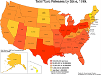
 Total Toxic Releases by State, 1999
Description: Total toxic releases by state, 1999.
Format: Color, 8.5" x 11", landscape.
JPEG  108 kb
PDF    112 kb
Data Source: 1999 Toxics Release Inventory.
Order Code: US-CE001

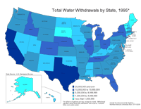
 Total Water Withdrawals by State, 1995
Description: Total water withdrawals by state, 1995.
Format: Color, 8.5" x 11", landscape.
JPEG   123 kb
PDF    124 kb
Data Source: U.S. Geological Survey.
Order Code: US-CE002

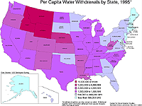
 Per Capita Water Withdrawals by State, 1995
Description: Per capita water withdrawals by state, 1995.
Format: Color, 8.5" x 11", landscape.
JPEG   114 kb
PDF    112 kb
Data Source: U.S. Geological Survey.
Order Code: US-CE003

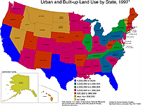
 Urban Land Use by State, 1997
Description: Urban and built-up land use by state, 1997.
Format: Color, 8.5" x 11", landscape.
JPEG   121 kb
PDF    112 kb
Data Source: U.S. Department of Agriculture.
Order Code: US-C004

1    2    Next >


   Illinois
   Basemaps
   Agriculture
   Climate/Environment
   Counties/Metro Areas
   Crime/Public Safety
   Demographic
   Economic
   Education
   Federal Expenditures
   Health/Vital Statistics
   Historical
   Housing/Construction
   Income/Poverty
   Labor Market
   Physical Features
   Political
   Recreational
   Transportation
   United States
   Basemaps
   Agriculture
   Climate/Environment
   Crime/Public Safety
   Demographic
   Economic
   Education
   Federal Expenditures
   Health/Vital Statistics
   Historical
   Housing/Construction
   Income/Poverty
   Labor Market
   Physical Features
   Political
   Recreational
   Transportation
   Utilities
 
    Please report problems to the webmaster.
    Copyright © 2001-2008 by the Regional Development Institute, Northern Illinois University.