U.S. Demographic Maps
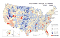
Total Population, Percent Change (2000-2003)
Description: Percent change in total population from 2000 to 2003 by county.
Format: Color, 11" x 17", landscape.
JPEG
244 kb
PDF
307 kb
Data Source:
U.S. Census Bureau.
Order Code: US-DM001
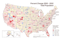
Total Population, Percent Change (2000-2002)
Description: Percent change in total population from 2000 to 2002 by county.
Format: Color, 11" x 17", landscape.
JPEG
230 kb
PDF
303 kb
Data Source:
Center for Governmental Studies.
Order Code: US-DM002
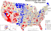
Total Population, Percent Change (1990-2000)
Description: Percent change in total population from 1990 to 2000 by county.
Format: Color, 11" x 17", landscape.
JPEG
224 kb
PDF
304 kb
Data Source:
Center for Governmental Studies.
Order Code: US-DM003
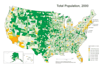
Total Population, 2000
Description: U.S. Total population by county, 2000.
Format: Color, 11" x 17", landscape.
JPEG
250 kb
PDF
304 kb
Data Source:
U.S. Census Bureau.
Order Code: US-DM004
1
2
3
4
5
Next
>
Illinois
Basemaps
Agriculture
Climate/Environment
Counties/Metro Areas
Crime/Public Safety
Demographic
Economic
Education
Federal Expenditures
Health/Vital Statistics
Historical
Housing/Construction
Income/Poverty
Labor Market
Physical Features
Political
Recreational
Transportation
United States
Basemaps
Agriculture
Climate/Environment
Crime/Public Safety
Demographic
Economic
Education
Federal Expenditures
Health/Vital Statistics
Historical
Housing/Construction
Income/Poverty
Labor Market
Physical Features
Political
Recreational
Transportation
Utilities
Please report problems to the
webmaster
.
Copyright © 2001-2008 by the
Regional Development Institute
,
Northern Illinois University
.