U.S. Climate and Environment Maps
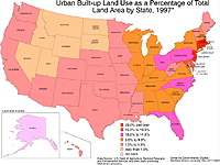
Urban and Built-up Land Use as a Percentage of Total Land
Area by State, 1997
Description: Urban and built-up land use as a percent of total land area by state, 1997.
Format: Color, 8.5" x 11", landscape.
JPEG
119 kb
PDF
112 kb
Data Source:
U.S. Department of Agriculture
, 1997.
Order Code: US-CE005
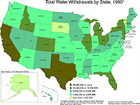
Total Water Withdrawals by State, 1990
Description: Total water withdrawals by state, 1990.
Format: Color, 8.5" x 11", landscape.
JPEG
114 kb
PDF
112 kb
Data Source:
U.S. Geological Survey
.
Order Code: US-CE006
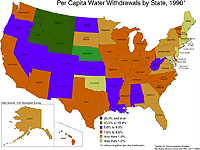
Per Capita Water Withdrawals by State, 1990
Description: Per capita water withdrawals by state, 1990.
Format: Color, 8.5" x 11", landscape.
JPEG
114 kb
PDF
112 kb
Data Source:
U.S. Geological Survey
.
Order Code: US-CE007
<
Back
1
2
Illinois
Basemaps
Agriculture
Climate/Environment
Counties/Metro Areas
Crime/Public Safety
Demographic
Economic
Education
Federal Expenditures
Health/Vital Statistics
Historical
Housing/Construction
Income/Poverty
Labor Market
Physical Features
Political
Recreational
Transportation
United States
Basemaps
Agriculture
Climate/Environment
Crime/Public Safety
Demographic
Economic
Education
Federal Expenditures
Health/Vital Statistics
Historical
Housing/Construction
Income/Poverty
Labor Market
Physical Features
Political
Recreational
Transportation
Utilities
Please report problems to the
webmaster
.
Copyright © 2001-2008 by the
Regional Development Institute
,
Northern Illinois University
.