U.S. Economic Maps
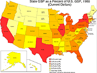
State GSP as a Percent of U.S. GSP, 1980
Description: State GSP as a percent of U.S. GSP (current dollars), 1980.
Format: Color, 8.5" x 11", landscape.
JPEG
120 kb
PDF
112 kb
Data Source:
U.S. Bureau of Economic Analysis
, 1999.
Order Code: US-EC005
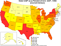
State GSP as a Percent of U.S. GSP, 1990
Description: State GSP as a percent of U.S. GSP (current dollars), 1990.
Format: Color, 8.5" x 11", landscape.
JPEG
118 kb
PDF
112 kb
Data Source:
U.S. Bureau of Economic Analysis
, 1999.
Order Code: US-EC006
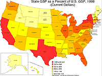
State GSP as a Percent of U.S. GSP, 1998
Description: State GSP as a percent of U.S. GSP (current dollars), 1998.
Format: Color, 8.5" x 11", landscape.
JPEG
119 kb
PDF
112 kb
Data Source:
U.S. Bureau of Economic Analysis
, 1999.
Order Code: US-EC007
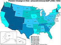
Percent Change in Real Gross State Product, 1990-1998
Description: Percent change in real Gross State Product (chained 1996 dollars), 1990-1998.
Format: Color, 8.5" x 11", landscape.
JPEG
111 kb
PDF
112 kb
Data Source:
U.S. Bureau of Economic Analysis
, 1999.
Order Code: US-EC008
<
Previous
1
2
3
4
5
6
Next
>
Illinois
Basemaps
Agriculture
Climate/Environment
Counties/Metro Areas
Crime/Public Safety
Demographic
Economic
Education
Federal Expenditures
Health/Vital Statistics
Historical
Housing/Construction
Income/Poverty
Labor Market
Physical Features
Political
Recreational
Transportation
United States
Basemaps
Agriculture
Climate/Environment
Crime/Public Safety
Demographic
Economic
Education
Federal Expenditures
Health/Vital Statistics
Historical
Housing/Construction
Income/Poverty
Labor Market
Physical Features
Political
Recreational
Transportation
Utilities
Please report problems to the
webmaster
.
Copyright © 2001-2008 by the
Regional Development Institute
,
Northern Illinois University
.