


|
Illinois Agricultural Maps
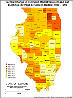
Estimated Market Value of Land and Buildings,
Percent Change 1987 - 1992 |
| Description: Percent change in estimated market value of land and buildings (average per acre in dollars). Illinois by county, 1987 - 1992. |
| Format: Color, 8.5" x 11", portrait. |
JPEG 140 kb
PDF 41 kb |
| Data Source: U.S. Dept. of Agriculture; 1997 Census of Agriculture. |
| Order Code: IL-AG025 |
|
 |
|
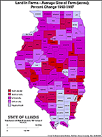
Land in Farms - Average Size of Farms (acres),
Percent Change 1992 - 1997 |
|
|
 |
|
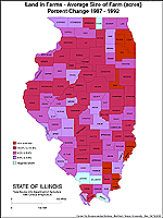
Land in Farms - Average Size of Farms (acres),
Percent Change 1987 - 1992 |
|
|
 |
|
|

|