 What are Wetlands?
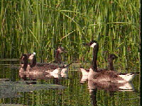
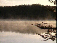
Wetlands encompass a variety of areas commonly known as marshes, bogs, wet meadows, swamps,
shallow ponds, and bottomland forests. Wetlands are periodically or permanently saturated with
water or covered by shallow water, and most are characterized by water-tolerant plants and poorly
drained soils. Historically, wetlands were considered mosquito-filled wastelands and obstacles to
development. Many wetlands were thus drained, filled, or otherwise altered. In recent years,
however, wetlands have been recognized as valuable areas that help to control floods, recharge
groundwater supplies, improve water quality, reduce erosion, create wildlife habitat, and provide
recreational, educational, and aesthetic opportunities.
The History of Wetlands in Illinois
Wetlands once covered more
than 8 million acres of Illinois, or approximately one-fourth of the state. An estimated 90% of the
original wetlands, however, have been destroyed by human activities, and only about 918,000 acres
remain (accounting for 2.6% of the state's area). Wetlands in Illinois have been affected
principally by the conversion of land for agricultural purposes, though in some areas urban
development has been predominantly responsible for wetland destruction and degradation.
 The Illinois Wetlands Inventory
To document the status of this rapidly disappearing resource, the Illinois Wetlands Inventory (IWI) was
developed. The IWI is an effort to locate, classify, and map the state's wetlands and deepwater
habitats (lakes and rivers). It is based on the National Wetlands Inventory (NWI) developed by the
U.S. Fish and Wildlife Service.
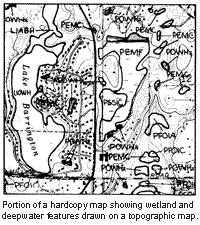
Inventory maps were produced from high-altitude infrared photographs taken between 1980 and 1987,
soil and topographic maps, and field investigation. Wetland and deepwater features were mapped on
U.S. Geological Survey 7.5-minute quadrangle (1:24,000 scale base maps. Each wetland and deepwater
feature is described by an NWI classification code. The code describes ecological and physical
characteristics such as dominant vegetative form (e.g., forest, emergent), substrate type (e.g.,
rock bottom, unconsolidated bottom), hydrology (e.g., temporary, seasonal, permanent), and human
effects (e.g., impounded, excavated, partially drained).
Wetland and deepwater features on the inventory maps were converted to computer-based data
through a process called digitization; that is, the lines on the maps were traced with an electronic
cursor and translated into a series of "X,Y" coordinates. The computerized inventory stores spatial
data (location and shape of features) and accompanying descriptive data (e.g., area, perimeter, NWI code)
for each wetland and deepwater feature. The computerized form of the inventory has many advantages
over conventional maps, including: ease of data update and enhancement ability to combine data into
geographic coverages other than 7.5-minute quadrangles (e.g., counties and watersheds); flexibility
in data analysis ability to integrate the wetlands data with other computerized data sets. As a
component of the Illinois Geographic Information System, the IWI can use a large number of other
coverages, such as roads, streams, and county boundaries. As a comprehensive resource inventory,
the IWI provides valuable information to resource planners, managers, environmental scientists,
policy makers, and others, and it will be an important source of baseline information for future
analyses of wetland trends. The IWI was not intended to delineate regulated wetlands, a determination
that should be made on-site.
How to Obtain Inventory Maps and Data
The IWI data are
available for purchase as hardcopy maps or in digital form. Hardcopy maps are available by
7.5-minute quadrangle and consist of wetland and deepwater features drawn on topographic base maps.
The maps are useful for small-scale projects. To order maps, first determine the appropriate map
names by referring to the Index of Topographic Maps of Illinois by visiting the Illinois State
Geological Survey web site (
http://www.isgs.uiuc.edu/quads/by-county.html ); then download the
order form. For further information or assistance, contact:
Ms. Sandy Petit, Wetlands Map Coordinator
Regional Development Institute
Northern Illinois University
148 North Third Street, DeKalb, Illinois 60115-2854
Phone: 815-753-1907
Fax: 815-753-2305
E-mail:spetit@niu.edu
Digital data are stored as ARC/INFO coverages. These data can be converted to several formats and
are available by 7.5-minute quadrangle, county, or watershed. Charges vary based on computer time,
labor, media, and delivery costs. The automated data are especially useful for large-scale projects
(e.g., state-wide, watersheds) and geographic information system applications. To order digital data
or obtain additional information about the Illinois Wetlands Inventory, please contact:
Mr. Marvin Hubbell
Illinois Department of Natural Resources,
Office of Resource Conservation
600 North Grand Avenue, Springfield, Illinois 62706
Phone: 217-785-8287
E-mail: wetlands@dnrmail.state.il.us
|