Illinois Demographic Maps
Illinois Population by County, Percent Change, 2000-2006
Description: Percent change in the resident population by county based on 2006 estimates.
Format: Color, 8.5" x 11", portrait.
JPEG
93 kb
PDF
40 kb
Data Source:
U.S. Census Bureau
, 2007.
Order Code: IL-DM005
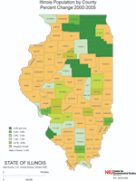
Illinois Population by County, Percent Change, 2000-2005
Description: Percent change in the resident population by county based on 2005 estimates.
Format: Color, 8.5" x 11", portrait.
JPEG
93 kb
PDF
40 kb
Data Source:
U.S. Census Bureau
, 2006.
Order Code: IL-DM006
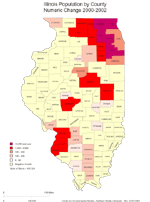
Illinois Population by County, Numeric Change, 2000-2002
Description: Numeric growth of the Illinois population by county based on 2002 estimates.
Format: Color, 8.5" x 11", portrait.
JPEG
93 kb
PDF
40 kb
Data Source:
U.S. Census Bureau
, 2003.
Order Code: IL-DM007
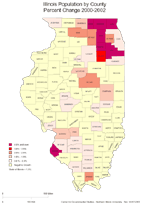
Illinois Population by County, Percent Change, 2000-2002
Description: Percentage growth of the Illinois population by county based on 2002 estimates.
Format: Color, 8.5" x 11", portrait.
JPEG
89 kb
PDF
40 kb
Data Source:
U.S. Census Bureau
, 2003.
Order Code: IL-DM008
<
Previous
1
2
3
4
5
6
Next
>
Illinois
Basemaps
Agriculture
Climate/Environment
Counties/Metro Areas
Crime/Public Safety
Demographic
Economic
Education
Federal Expenditures
Health/Vital Statistics
Historical
Housing/Construction
Income/Poverty
Labor Market
Physical Features
Political
Recreational
Transportation
United States
Basemaps
Agriculture
Climate/Environment
Crime/Public Safety
Demographic
Economic
Education
Federal Expenditures
Health/Vital Statistics
Historical
Housing/Construction
Income/Poverty
Labor Market
Physical Features
Political
Recreational
Transportation
Utilities
Please report problems to the
webmaster
.
Copyright © 2001-2009 by the
Center for Governmental Studies
,
Northern Illinois University
.